
Weather information for the Sheboygan area is provided below. Average temperatures, climate details and current forecasts are included!

Go-Wisconsin


-
Places To Go
- Sheboygan Links
- Statewide Links
A summary of what Sheboygan has to offer.
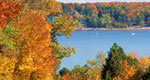
Artists' retreat and natural beauty, Door County has in addition to lovely landscapes a range of historic sights, miles of hiking trails and plenty of places to put in a boat.
-
Things To Do
-
Sleep + Eat
- Sheboygan Links
- Statewide Links
Searchable listings of Sheboygan hotels, motels, resorts, bed & breakfast, and more.

Use our easy Lodging Search to find exactly the type of accommodation you are looking for at the right price.
Search Now- Travel Planning
- Sheboygan Links
- Statewide Links
Travel articles related to Sheboygan…
Sheboygan weather report, historic temperatures and climate info,…
Searchable lists of Sheboygan tourism offices and other helpful government agencies.
Explore destinations near Sheboygan.

- Photos + Videos
- Sheboygan Links
- Statewide Links

Blue Harbor Resort
Sheboygan River
Sheboygan Waterfront
Request Free Visitor Guides
1
Select a Free Visitor Guide below2
Complete the form to receive your guides by mailBelow are the Free Visitor Guides for Wisconsin Area. Click here to view all the guides avialable for Wisconsin.
In Depth


Copyright 1997 - 2026 The Go Travel Sites. All Rights Reserved and.