
Weather information for the Door County area is provided below. Average temperatures, climate details and current forecasts are included!

Go-Wisconsin


-
Places To Go
- Door County Links
- Statewide Links
A summary of what Door County has to offer.
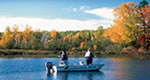
Stand-out snowmobiling destination that moonlights as a fishing hot spot in warmer months, Eagle River is a stone's throw from a 500-mile trail system and a long chain of freshwater lakes.
-
Things To Do
-
Sleep + Eat
- Door County Links
- Statewide Links
Searchable listings of Door County hotels, motels, resorts, bed & breakfast, and more.
Searchable listings of Door County RV parks and campgrounds.

Use our easy Lodging Search to find exactly the type of accommodation you are looking for at the right price.
Search Now- Travel Planning
- Door County Links
- Statewide Links
Door County weather report, historic temperatures and climate info,…
Searchable lists of Door County tourism offices and other helpful government agencies.
Explore destinations near Door County.

- Photos + Videos
- Door County Links
- Statewide Links

Door County Autumn
Ephraim, Wisconsin
Potawatomi State Park
Request Free Visitor Guides
1
Select a Free Visitor Guide below2
Complete the form to receive your guides by mailBelow are the Free Visitor Guides for Wisconsin Area. Click here to view all the guides avialable for Wisconsin.
In Depth


Copyright 1997 - 2026 The Go Travel Sites. All Rights Reserved and.