


Contact Info
1166 Fourth Avenue South
Park Falls, WI 54552
- Phone:
- 715-762-2461
Basics
- Length:
- 11 miles
- Difficulty:
- Easy
- Time:
- 4 - 5 hours
Description
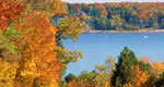
This 11 mile trail system provides access to the 3600-acre Round Lake Semi-Primitive Non-Motorized Area. This unique area has numerous foot trails and old road grades. The area contains the origin of the South Fork of the Flambeau River; stands of towering, old-growth white pine and hemlock forests surrounding Tucker Lake; and a restored logging dam dating back to the 1800's. The trail terrain varies from fairly gently rolling slopes and steeper ridges to occasional low wet areas. Camping is permitted throughout the area with several spots having been cleared for primitive camping. There is a lot of human history associated with this area and when walking along the trails you can almost conjure up what it was like during the logging era of the 1800's.

