


Contact Info
- Phone 1:
- 715-634-4821
Basics
- Number of Sites:
- 52
Amenities
Basic Amenities
- Drinking Water
- Vault Toilets
Special Features
- Playground
- Fishing
Additional Conveniences
- Boat Ramp
Details
Season
Open through Sat Oct 19 2013Location
Getting There:GPS Info. (Latitude, Longitude):
46.17639, -90.90917
46°10'35"N, 90°54'33"W
From Clam Lake, Wisconsin, travel a mile north on Highway GG.
Basic Info
- Total Sites:
- 52
A boat ramp and picnic area with beach access are located two miles south of the campground, on County Highway M.
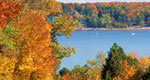
The 640-acre lake is a popular destination for anglers, with musky, bass and panfish available in abundance. The area is also ideal for kayaking, canoeing and swimming. Elk, eagles, loons and other wildlife are often spotted in the area.

